Tubal Cain Mine History
This excellent article about the history of
the Tubal Cain Mine and the surrounding area was printed in the Peninsula Daily
News on February 17, 2013. The author, Pam Clise, generously consented to
let me post the article on my website. Pam is a historian who lives in
nearby Port Townsend. Her history column, Back When, appears once a
month in the Peninsula Daily News.
I hope you enjoy it as much as my wife,
Elna, and I did.
History
Wends Along Mountain Trails
Peninsula
Daily News Back When - February 17, 2013
Pam
McCollum Clise
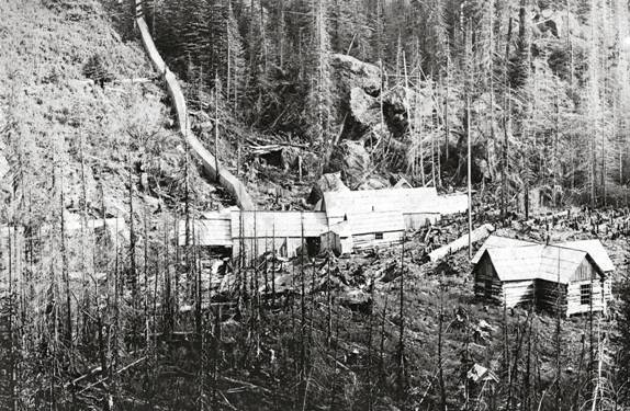
This
1907 post card view of Tubal Cain Mine shows the snow shed and a tunnel that
enabled workers to access the mine in bad weather. .
Courtesy Jefferson County Historical Society.
It
was the late 1800s when Silas Marple, a man from Brinnon, went exploring up
the Big Quilcene River in and around the amazing area of the Olympic Mountains
near Buckhorn peak. He saw not only
the beauty of the mountains and lakes but the possible riches in the rocks right
in front of him.
He was not the first person in the area hoping to mine the mountains for
dreamed-of-riches, yet his vision grew into what would later become the Tubal
Cain Copper and Manganese Mining Company.
Silas filed his first mining claims in 1901, and word began to move
through the area that riches could be found in the mountains.
Within another year, there were hundreds of claims filed in the area.
Dreams
of riches
By the summer of 1903, the
newspapers were shouting about iron, manganese and cooper for the digging.
Silas convinced a group of investors and adventurers that his claims
would serve them all well. The
chance-takers included Frank Hanford, Charles Denny, Victor Tull, Judge
Albertson, and I. A. Nadeau.
Wasting no time, the Tubal Cain mining endeavor began digging out two
tunnels -one for copper, and one for manganese- according to the Port
Townsend Leader, and had 12 men working on what had quickly become known as
Iron Mountain.
Iron Mountain itself was a rugged 4-mile-long,
1-mile-wide piece of rock that lent itself to the idea of drilling right through
both sides to bring out its riches.
Hardships began earlier with the cutting of trails up to the miming areas.
The earliest route is thought to be one that was about 25 miles up along
the Big Quilcene River, over passes and around Iron Mountain.
A shorter route about 18 miles up the Little Quilcene River took its
place within a very short time going to the mines known as Copper City and Tull
City. Copper City was later just
called Tubal Cain.
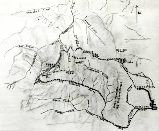
Map,
drawn in 1909, encompasses Quilcene, Tubal Cain and Tull City.
Courtesy Jefferson County Historical Society.
All supplies, including
equipment, heavy tools, and dynamite had to be brought up on burros, providing
lucrative jobs for industrious packers in the area.
The heaviest equipment was brought in on two burros with poles strung in
between them to carry the weight.
Fading hopes
Even with high hopes, good
samples and a flurry of mining activity all around the area, the mines did not
produce to any ones satisfaction. After
a fire, an avalanche, and a rebuilding of some of the structures, the mines were
basically defunct by the end of World War I.
The buildings began to crumble, the mines began to
cave in, and the many once hopeful dreams moved on.
In 1926, a company headed by Alfred Foster began
buying up stock of the major mines.
In the summer of 1930, the Leader reported that the Olympic Manganese Mining Co. was about to
reopen Tubal Cain and new road options from either Discovery Bay or Sequim were
being explored.
In the winter of 1952, the Leader reported a plane crash in Tull Canyon very close to old
mines. The B-17 hit part of a ridge
in a blinding blizzard with extremely high winds and non-working radio.
The plane skidded down the mountain, killing three of eight crewmembers.
'Trail of
debris'
The article stated: "It was estimated
the big plane slid down the mountain a thousand feet, leaving a trail of debris
as it bounced and tumbled, finally coming to rest in a box valley".
The survivors were located and
helicoptered out the next day after making a shelter with parachutes and using a
lifeboat at their floor. A separate
rescue team was flown in to search for the three missing men, whom they located
the following day in various locations down the mountainside.
Don
Crippen, currently of Montana, recalls that the Air Force hired Ed Nicodym, a
commercial packer, to bring out the radar equipment. A
year later, when Don went to the site with Ed and Pearl Nicodym, survival gear
could still be found at the crash site as well as many K-rations.
Many local people have been hiking and
exploring the area for many years. Eva
Cook Taylor, famed adventurer of the Olympics on mule back, wrote about,
collected photographs of and heavily explored this side of the Olympic
Mountains. Her nephew, Bud Brown,
and his son Rich Brown, continued to hike, explore, fish, and keep historical
records of the area.
Rest stop
Bud Brown began using Tubal
Cain Mine as a stop- off place to the Olympics in about 1955, just a few years
after the B-17 crashed. His ultimate
destination was usually Buckhorn and Silver Lakes for fishing.
There was no easy way to get up there at that time and he often used the
Little Quil and Dirty Face Ridge trail.
During the 1950s, many of the mine buildings were still in place with lots
of machinery, pipes and other thing's used during the early days at the mine,
still there. He marvels at who ever
hauled out all the heavy pieces that disappeared over the years.
Little was ever heard about the 1930 efforts of the
Olympic Manganese Mining Company and the company was sold for $5,000 in 1956.
In 1969, Glenn Huntingford and Bob Shold hiked up to
Tubal Cain in the summer of their Freshman year in high school They went up the
Little Quilcene Trail, down Dirty Face Ridge and later came out at 10-mile
shelter.
Camper
A-frames
At the time, the 14-year-old
boys found small camper A-Frames that had been put together roughly from
remnants of the old Tubal Cain mine buildings.
The shelters were built off the ground to help keep wild animals out as
much as possible. There was enough
room to throw a couple of sleeping bags down out of the weather.
The mine tailings that spilled out of the tunnel
entrance provided an excellent place for the boys to run and slide down
repeatedly.
Most of the buildings were gone by this time, although more had been there
just a few years previous to this time. At
the mine entrance, old jackhammers still lay nearby.
The boys explored Tull Canyon and found many of the Tull City buildings,
located about a half-mile from Tubal Cain, still in place in 1969.
Glenn hiked up to the area every summer while in
high school, never tiring of exploring the area.
Hiking the area continued to be a tradition in Glenn's family.
He, his wife, Barbara, and their kids spent many summery adventures
sleeping under the stars with sleeping bags laid out on the sandbar next to
Cooper Creek running in front of the Tubal Cain mine site.
Steve Ricketts of Chimacum, historian and volunteer
for the Jefferson County Historical Society, recalls his several visits to the
Tubal Cain area that can now be reached much more easily by driving up the
Dungeness River road to the Tubal Cain trailhead at the Silver Creek Shelter.
"The drive in and hike are now pretty easy and nice to Tubal Cain
from the trailhead, while the trail to Tull Canyon is much steeper. I
followed the old pipe that runs across the trail downhill about a 100 yards
where I was able to explore the remnants of the Pelton Wheels at the
creek."
The wheels were a part of the mill to create
electricity for the sawmill as well as pumping air into the mines for workers.
Exploration
team
Virginia "Ginny" Jennings
first
went up to the Tubal Cain area about 1988. She
was part of exploration team from the Jefferson County Historical Society in
1997 that included then-director, Niki Clark, Steve Ricketts, Erin Mullen, and
Bob McDole. Tull City buildings
still were visible with foundations and some walls about four logs high. The
old A-frame lean camp buildings were long gone.
Although interesting, her favorite part of the Tubal Cain Mine trail was
going up beyond it towards Buckhorn in July when the wild flowers are
spectacular. Summer hiking along the
Tubal Cain trail offers many views of wild Rhododendrons as well.
Generation after generation hike and explore the
Olympic Mountains and marvel at the dreams, trials, and fortitude of people who
in the past were looking for riches in these mountains.
More than 200 acres of the original Tubal
Cain holdings are still in private hands after being sold several times.
For the most part, the mines have a lot of standing water and weak walls,
where they are left standing.
Tull City still has foundations and a few logs showing the location of a
couple of its original buildings.
The private-property mines are unsafe, the history
exciting, and the buildings are only a faint outline of grand plans and
potential riches.
Thanks
go to Eva Cook Taylor and great-nephew Rich Brown for preserving and sharing so
much history of Tubal Cain.
Pam's email address is pamm@olympus.net
if you would like to email her about this article.